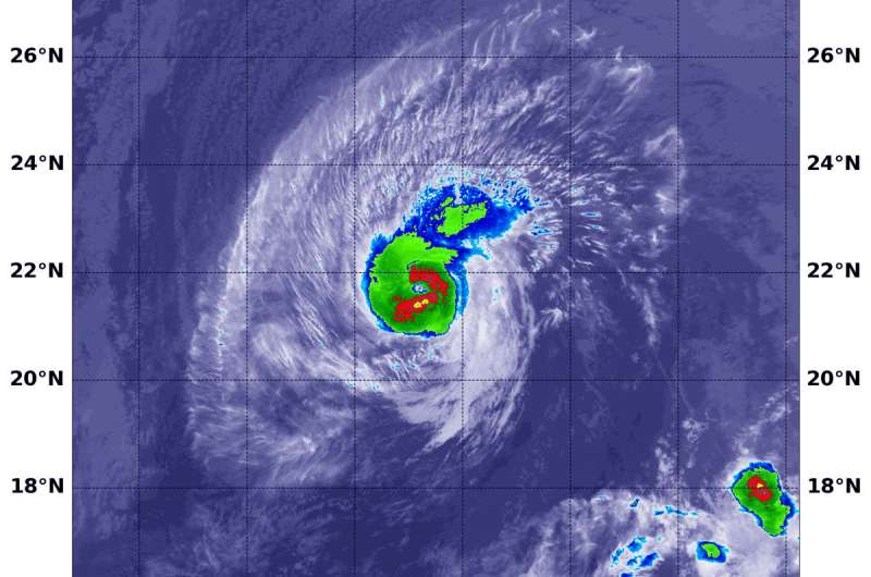
NASA tracking Hurricane Olivia's track toward Hawaii

Hurricane Olivia moved from the Eastern Pacific into the Central Pacific and is expected to affect Hawaii. NASA's Aqua satellite the northeast and southwestern quadrants of the storm to be the most powerful on Sept. 10.
Infrared satellite data at 12:15 a.m. EDT (0415 UTC) on Sept. 10 from the Moderate Resolution Imaging Spectroradiometer or MODIS instrument aboard NASA's Aqua satellite revealed the strongest storms were southwest and northeast of the center. In those areas MODIS found coldest cloud tops had temperatures near minus 70 degrees Fahrenheit (minus 56.6 degrees Celsius). NASA research has found that cloud top temperatures that cold have the capability to generate heavy rainfall.
The MODIS data showed that the strongest storms only extended out 30 miles from the center. Hurricane-force winds extend outward up to 30 miles (45 km) from the center and tropical-storm-force winds extend outward up to 115 miles (185 km).
The Central Pacific Hurricane Center of CPHC noted a Tropical Storm Warning is in effect for Hawaii that covers Maui County, including the islands of Maui, Molokai, Lanai, and Kahoolawe and Hawaii County. A Tropical Storm Watch is in effect for Oahu.
At 11 a.m. EDT (1500 UTC/5 a.m. HST), the center of Hurricane Olivia was located near latitude 21.7 degrees north and longitude 148.0 degrees west. Maximum sustained winds are near 85 mph (140 kph) with higher gusts. Little change in strength is forecast today, with slight weakening starting tonight and continuing through Tuesday. However, Olivia is forecast to be a strong tropical storm when it reaches the Hawaiian Islands.
Olivia is moving toward the west near 10 mph (17 kph). This general motion is expected to continue early today, followed by a turn toward the west-southwest starting later today. This west-southwest motion is expected to continue through Tuesday night. On this forecast track, tropical storm conditions are expected over parts of Hawaii starting late Tuesday.
Provided by NASA's Goddard Space Flight Center


